Haleakela
For years my brother and I had talked about the possibility of cycling in Maui, where one can cycle from sea level to more than 10,000 feet in less than 40 miles. At some point in 2014, we said “you know, if we are ever going to do that, we should perhaps get going.” In August 2015, we did it. It was a great day, perhaps the greatest athletic day of my life. For some reason I have not posted about it here. So I am taking an email that I sent a few days after the event, editing it lightly, and posting it now.
We brought our pedals and cycling shoes, but not our bicycles, to Maui. We rented road bicycles from West Maui Cycles, a great bike store, on the day before the ride, so that we could get an early start. We left our condominium about six and arrived at the start point, the little village of Paia, about seven, just as the sun was coming up. My brother insisted on dipping his toe in the ocean, so that he could say he had gone from sea level, not merely close to sea level. Of course, as an oceanographer, he knows that sea level is sometimes a foot or two below the level of the sea on the beach, but never mind, we have the photo of him with his foot in water.
The road starts going uphill instantly. You start through the little town, past stores and schools and churches. Then cane fields; large parts of Maui are still sugar cane fields; not sure whether that is due to federal tariffs or whether the planters have somehow managed efficiencies that enable them to compete with Philippines. The only other town you pass through, Makawao, comes at about mile six, and in the morning it was quite dead; stores and a gas station.
The first real hill comes just as you leave Makawao; you have been coasting along at 4 or 5 percent grade, uphill but not really hard, and then suddenly it kicks up for a quarter mile to something like 12 percent. Ouch. But pretty soon it gets less steep, as you ascend through a mixture of meadows and forests. Cattle ranches, large houses with views out over the cane fields to the ocean, and great tall eucalyptus trees. You make a right turn at mile 8, really the only bit of the road you could miss, and then join the Haleakala highway. Sort of obvious.
Up and up, not steep, but steadily up. At mile 16, still in mixed residential and ranches, you take a turn onto the Crater Highway. Again, sort of obvious. You are now at about 3000 feet of elevation, and the road gets a little steeper, but only a little; the first 16 miles have average grade of 4 percent and the last 21 miles have average grade of 6 percent.
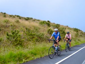
Now the switchbacks start in earnest, at first among houses with pleasant little gardens, one with Buddhist prayer flags, a couple with little informal fruit stands out by the road. The houses thin out and you are in cattle country; a sign by the side says “beware of dogs guarding livestock.” At this point, for us, we were in a bit of cloud cover, not dense, but somewhat cool. I have read that it can be really cold and wet.
Up and up, still not that steep. Every 500 feet of elevation, in this part, is marked, and some points are marked more than once. At 4000 feet there were three marks; one placed on the pavement by the race organizers, one on a sign by the highway engineers, and one on a mail box by a resident. Fewer and fewer houses, more and more grass, wider and wider views back down to the ocean and up to the mountain. We could, by this point, see the top; the observatory was emerging and disappearing in the clouds every few minutes. It did not look that far away, but it was definitely a long way above us. It was so far away that I was not sure that it was the observatory but my brother, with better eyes, assured me that it was.
Up and up, with every mile marked and noted, with my sister-in-law (God bless her) waiting for us with Gatorade every three or four miles at this point. My brother was having more difficulty than I was, needing the rest stops, needing to rest longer. We were cycling behind another guy, and my sister-in-law would tell us that “West Texas,” her nickname for him, was ten minutes ahead, five minutes ahead, two minutes ahead. I was keen to catch him, my brother was keen to conserve energy.
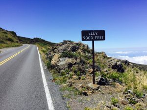
Up and up, and now we entered the national park and paid our entry fee. The fee was $8 per bicycle, I gave her a $20 and told her to keep the change. At this point there was still grass on either side of the road, thick green grass, but more and more often you can see the red lava through the grass, the grass is getting sparser and the lava more notable. The park service still has the elevation markers; the entrance station is at 6500 feet, so we knew that we still had another 3500 feet of climbing, even though the observatory seemed closer every time we look at it.
The wind is stronger here, and we take turns breaking the wind, especially when we turn to the east, more into the wind. By this point I know I can do it, and am eager to get on with it, but Fritz is breathing hard, so I stay with him. We stop again at 8500 feet, where my wife and daughter are there to cheer us on. We catch up to West Texas, whose real name is David, and we pull him along, tell him that we are almost there, as indeed we are. We can almost touch the observatory now, it seems to me, although it is a little like the Emerald City for Dorothy; it LOOKS closer than it is.
Up and up, and now we are at the upper visitor center, about 9500 feet of elevation. We can see the top now, which is not really the observatory, it is a small structure that looks like a bunker, just above us. My brother and David say they need to breathe a minute, that I should go for it, and I do, standing up to kill the last few meters.
I quickly sit down again: the last few meters are the hardest, steepest bit of the ride. It is as if the engineers, after trying to avoid steep grades for miles, said “what the heck, let us just get to the damn top of the mountain.” So I sit down and turn the cranks, turn the corner and there it is; the parking lot at the top. My mother and sister-in-law and others are cheering, and I am there. Well, not quite. When my brother arrives he insists that we ride the sidewalk up to the top, to the bunker, because the parking lot is ONLY at 9975 feet, whereas the bunker is at 10,023 feet, and of course one wants that, right? So we ride up through the pedestrians, start snapping pictures there, with the sign behind us, our smiles wide but our faces sort of pinched, as one might expect after five hours of hard cycling.
We had a sort of lunch with our family up there in the cars, Gatorade and energy bars for us, more civilized food for them. Then suiting up in warm clothes for the descent; it was not really cold up there, like it can be, but perhaps 55 degrees with 25 miles an hour of wind, not exactly warm. I put on a thick long sleeve jersey and tights over my cycling shorts and long fingered gloves and that was about right.
What a descent. You may have heard that it is possible to do the descent with a commercial company, but that is not really right; the park service, after a death a few years back, closed the park road to commercial companies, so the first 3500 of downhill are “reserved” for those who have ridden up themselves. The signs say 15 mph, but that is not right; you can take the whole thing at about 30 to 35 mph, because the road is so flat. Well, not really, but not a cliff like the California roads on which I have been training.
After 21 miles, at the intersection, we met my sister-in-law again, and stripped out of our warm clothes. Soon back at the bike store, where we turned in the rented bikes and then took another photo, near the beach: done.
My sister-in-law, God bless her, snapped hundreds of pictures, and she made one of them into my favorite cycling jersey. You can see two small cyclists, creeping up a mountain, one in blue, my brother, one in red polka dots, me. The slogan reads “someday is today.” I am so thankful that we did it, and hope that, someday, we might do it again.